Chesapeake Bay Bridge

Note: The Chesapeake Bay region has two spectacular bridges. This page is about the Chesapeake Bay Bridge in Maryland. We also have a page about the Chesapeake Bay Bridge Tunnel, the Bay’s southern crossing that spans the mouth of the Chesapeake Bay.
About the Chesapeake Bay Bridge
The Chesapeake Bay Bridge, which takes Route 50 across the Chesapeake Bay between the Kent Island and Annapolis areas, is officially named The William Preston Lane Jr. Memorial (Bay) Bridge – but most locals refer to it simply as the “Bay Bridge,” or sometimes the Chesapeake Bridge. The bridge is named after William Preston Lane, Jr., who was the Governor of Maryland when construction of the first span began.
Two Spans, 4.2 Miles Long
The Bridge is 4.2 miles long – one of the longest over water structures in the world. The Bay Bridge is actually two side-by-side bridges with two lanes of traffic on each span. The first bridge (eastbound span) opened in July of 1952 and the second bridge (westbound span) opened in June of 1973.
Is the Chesapeake Bay Bridge Scary?
There’s been a lot of press about how the Bay Bridge is one of the scariest bridges in America. It is a tall bridge and a long bridge. If you have a fear of bridges or a fear of heights, then crossing the Bay Bridge may be uncomfortable for you. But for many people it’s not a big deal and can even be a pleasant experience. The key is to pay attention to traffic conditions and keep your eyes on the road. If you need help getting across the bridge, there is a service that will drive you across in your own car (see the “Assistance Driving Across the Chesapeake Bay Bridge” section below).
For passengers, the view from the Chesapeake Bay Bridge can be spectacular. The bridges rise 186 feet above the water, affording a bird’s eye view of the surrounding area. You will see lots of sail boats and other pleasure boats on the Bay during nice summer days. Note: Only passengers should be looking at the scenery – the bridges do not have full road shoulders and, therefore, do not offer motorists the same maneuvering space found on other roadways to avoid accidents, therefore it’s very important for drivers to keep their eyes on the road.
Traffic Direction
Most of the time, all the lanes on each span have traffic going in the same direction, but during rush hours and times of heavy weekend beach traffic, the lanes change direction to ease traffic congestion. The lanes are clearly marked with lighted marking to show which way to go. See the Driver Information section below for details.
Places to Stop on Either Side of the Bridge
Annapolis and Sandy Point State Park are located on the west side of the bridge. There are plenty of restaurants and hotels in the Annapolis area, plus historic downtown Annapolis is a nice place to visit. Sandy Point State Park has sandy beaches and great views of the bay.
On the eastern side of the bridge, the Kent Island area has hotels and waterfront restaurants, plus the Queenstown Premium Outlets are nearby.
Chesapeake Bay Bridge Tolls
The bridge toll is only collected one way. The toll booth is located on the western shore (Annapolis) side of the Bridge. Visit the Mdta website for the current toll rates.
The Bay Bridge operates on a cashless toll system. The EZPass Toll Collection System is used to collect tolls at the Bay Bridge. For those without EZPass, tolls are by video tolling (toll bill will be mailed to registered owner of vehicle).
Traffic Conditions
Chesapeake Bay Bridge Traffic. Current conditions, advisories, and best times to travel.
Important Driver Information
Here is some important Chesapeake Bay Bridge Information for drivers, provided by the Maryland Transportation Authority.
Drivers should maintain a higher level of awareness when traveling on bridges. For your safety and that of your passengers and fellow drivers:
-
Obey and maintain posted speed limits. Bridges do not have full road shoulders and, therefore, do not offer motorists the same maneuvering space found on other roadways to avoid accidents.
-
Obey overhead-lane-use-control signals for traffic control. The meanings of these overhead signals are as follows:
-

A steady DOWNWARD GREEN ARROW means that you are permitted to drive in the lane over which the GREEN ARROW signal is located.
-
A steady YELLOW X means that you should prepare to vacate the lane over which the YELLOW X signal is located and move to a lane with a DOWNWARD GREEN ARROW.
-
A steady RED X means that the lane is closed and you must not use it.
-
-
On the Bay Bridge, traffic speeds tend to vary due to traffic volume, bridge grade and curvature, and scenic vistas. Motorists should use extreme caution and resist the temptation to sightsee while on the bridge. Adherence to overhead-lane-use-control signals and posted speed limits is strictly enforced. Fines are doubled in workzones.
-
Drivers traveling the Bay Bridge should exercise special caution when a “two-way” traffic configuration is in effect.
-
When speed-limit signs are superseded by reduced speed limits on variable message signs, drivers must obey the reduced speed limit.
-
If you have a cellular telephone, please report disabled vehicles by dialing #77. If reporting an accident, call 911.
-
If your vehicle becomes disabled on the bridge, turn on your emergency flashers and wait for Maryland Transportation Authority Police assistance.

Bay Bridge Info

Traffic: Information about Chesapeake Bay Bridge traffic and the best times to cross the bridge.
Chesapeake Bay Bridge Hotline: 1-877-BAYSPAN
Chesapeake Bay Bridge Traffic Cam
(Live webcam views of Chesapeake Bay Bridge traffic on US Route 50 at Sandy Point)
Assistance Driving Across the Chesapeake Bay Bridge
We’ve had several requests for information from people who are afraid to drive across the bridge. The Kent Island Express offers drive over service for a fee. Call them at least one hour before your bridge crossing time. Visit the Kent Island Express website for details.
Area Travel Information
Kent Island, MD Visitor Information. The Kent Island/Stevensville/Grasonville area is on the eastern side of the Bridge. There are many restaurants and hotels concentrated in this area.
Annapolis, MD Visitor Information. The greater Annapolis area is located on the western side of the Bridge. This area has many hotels, restaurants, and the downtown Annapolis historic district.
Chesapeake Bay Bridge Traffic. Current conditions, advisories, and best times to travel.
Chesapeake Bay Weather. Weather conditions and reports.
Bay Bridge Outlets. Shop the Kent Island Area Outlets.
Chesapeake Bay Bridge Walk
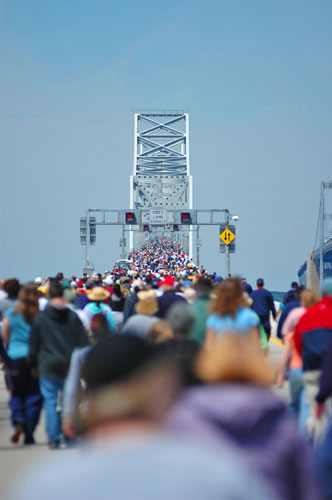
For many years the Chesapeake Bay Bridge closed one span to traffic for a day in order to let pedestrian walk the span. The walk was usually held on the first Sunday in May. The annual Bay Bridge Walk became a regional attraction that brought 40,000 to 60,000 participants each year to walk the bridge and enjoy the view. Two way traffic was handled on the second span during the walk. The walk is approximately 4.5 miles one way. Participants parked at one of the MdTA designated parking lots and took shuttle buses to the starting point of the walk. Shuttles returned participants to the parking lot after finishing the walk. The Bay Bridge Walk has been cancelled for the last several years due to on-going construction projects, security concerns, and cost concerns. This event has been replaced by an annual Across the Bay 10K.
The 2020 “Across the Bay 10K” is canceled. Visit the race website for details. The 10K is open to walkers, but there’s a time limit for completion of the course.
Additional Information
The William Preston Lane, Jr. Memorial Bridge. The official Maryland Transportation Authority website.
Live Chesapeake Bay Bridge Traffic Webcams. View the MdTA traffic cams for US 50 at Sandy Point (western shore side) and US 50 at MD 8 (eastern shore side).
Chesapeake Bay Bridge Facts and History. Wikipedia has a good article about the Bay Bridge including the history construction and renovations, plus some structural details.